 Anzac Hill and the Turkish cannon
Brewery and Butts Reserve
Denominational School
Derby Hill
Grave of Elisabeth Anset and son
Lake Cairn Curran
Maldon Cemetery
Mount Tarrangower and lookout tower
Reservoirs - original town reservoirs
Victorian Goldfields Steam Train
Anzac Hill and the Turkish cannon
The lookout by the "Gallipoli gun" provides a good lookout over the town
and is a popular place for artists and photographers who
want to capture a view of the town. The gun is of German
manufacture and was apparently captured in Palestine and
shipped to Australia at the end of the war. It was installed
in its present location as a memorial to the ANZAC troops.
Brewery and Butts Reserve
A picnic site and shelter at the start of the road to Mount Tarrangower.
The area was the location of a spring that provided an early
water supply for the town and the site of the Maldon
Brewery.
Denominational School
The building was erected in 1856 at a cost of £572 and was
used as a school house and meeting place for the Church of
England. It was partly demolished by a storm in 1857 and
rebuilt in 1862. The stonework is believed to have been done
by W Bowes and Sons. It functioned as a Church School until
1873 when it became the Maldon State School. The school
closed in 1875 with the opening of the Maldon State School
in High Street.
Derby Hill
The hill on the western side of Main street, overlooks the town, and on the
walking track around the hill can still be seen the remains
of several mines and a crushing battery.
Grave of Elisabeth Anset and son
The isolated grave in Chapel Street South is that of Elizabeth Anset (nee
Burton) aged 27 and her 14 day old son, who died on 19 July
1854. Before the Maldon Cemetery was established the area
around the grave site was the location of the Wesleyan
Church graveyard.
Lake Cairn Curran
The reservoir to the west of Maldon dams the Loddon River and takes its
name from the 100,000 acre original pastoral run Cairn
Curran that was established in 1840. The construction of the
reservoir was started in 1947 and was completed in 1956
using large numbers of European migrants. The water from the
reservoir is used for irrigation and the 4,800 acre facility
is also used for recreational boating and fishing.
Long Gully
The gully runs along the rear of the shops, on the Western side of Main
Street. The gully was the site of the first discovery of
alluvial gold in 1853 and at the peak of the gold rush was
worked by an estimated 20,000 diggers for several kilometres
of its length.
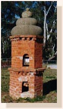
Maldon Cemetery
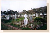 The cemetery's first interments were recorded in 1856 and the
cemetery was gazetted in 1860. The lodge was built around
1866 for use as the caretaker's house and the rotunda is
thought to have been built around 1900 to shelter mourners.
There have been over 5000 burials, including 121 Chinese.
There is also a large brick Chinese funeral oven of unusual
design that was for the burning of offerings to the spirits
of the dead.
The cemetery's first interments were recorded in 1856 and the
cemetery was gazetted in 1860. The lodge was built around
1866 for use as the caretaker's house and the rotunda is
thought to have been built around 1900 to shelter mourners.
There have been over 5000 burials, including 121 Chinese.
There is also a large brick Chinese funeral oven of unusual
design that was for the burning of offerings to the spirits
of the dead.
Mount Tarrangower and lookout tower
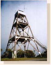 The Mount is 571 metres above sea-level and gives a 360° view to
a distance over 60 kilometres. The 24 metre lookout tower is
the poppet head from the Comet Mine in Bendigo and was
brought to Maldon in 1924. The sections of the tower were
brought by rail and then by horse drawn wagons to the Mount.
The tower is lit each year at the time of the Easter
Festival and is visible up to 60 kilometres away.
The Mount is 571 metres above sea-level and gives a 360° view to
a distance over 60 kilometres. The 24 metre lookout tower is
the poppet head from the Comet Mine in Bendigo and was
brought to Maldon in 1924. The sections of the tower were
brought by rail and then by horse drawn wagons to the Mount.
The tower is lit each year at the time of the Easter
Festival and is visible up to 60 kilometres away.
Reservoirs - original town reservoirs
Lack of water was always a problem in Maldon and its
goldfields. In its early years, water was provided by
several local springs and by water carted from the Loddon.
The town's first natural catchment reservoir was built in
1861 at a cost of £1,385 at the Western end of Adair Street.
The first reservoir leaked badly and a second reservoir was
constructed in 1876 at the end of Fountain Street. This
second reservoir supplied Maldon's water until 1884 when
water was piped in from Malmsbury. A pump was installed in
1896 in Long Gully to pump the water to a retaining basin
above the town.
Victorian Goldfields Steam Train
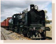 The Maldon Railway Station and the rail line to Castlemaine were
completed in 1884. The line ran 16 km to Castlemaine and
crossed 13 bridges and at its peak ran three times a day. A
branch line to Shelbourne was constructed in 1891. The line
was eventually closed in 1976 and was taken over by the
non-profit association Victorian Goldfields Railway who now
run it as a tourist attraction. The aim is to repair the
track and bridges to allow the train to run through to
Castlemaine.
The Maldon Railway Station and the rail line to Castlemaine were
completed in 1884. The line ran 16 km to Castlemaine and
crossed 13 bridges and at its peak ran three times a day. A
branch line to Shelbourne was constructed in 1891. The line
was eventually closed in 1976 and was taken over by the
non-profit association Victorian Goldfields Railway who now
run it as a tourist attraction. The aim is to repair the
track and bridges to allow the train to run through to
Castlemaine.
|
|
